Patrolfinder is the cutting-edge, patent-pending software solution at your officers’ fingertips. Accessed on the MDT (Mobile Data Terminal) of your patrol officers, Patrolfinder helps increase equitable policing, improve department transparency, improve officer safety and officer efficiency. Patrolfinder will help your officers make better decisions. The result: Better community relations and a safer city.
What is Patrolfinder?Patrolfinder is an award-winning revolutionary new policing software created to:
Patrolfinder will help ensure that your community is safer by making sure each corner of your region is being patrolled regularly. Using your city’s street maps, your department’s vehicles, patrol zones, and patrol goals, Patrolfinder provides patrol officers and administrators with insights into where and when patrols have occurred. |
With this information departments can better serve communities, officers can more efficiently patrol, and administrators can analyze coverage and observe real-time patrol.
 Using NFC technology, Patrolfinder can be used by security teams and patrol officers to record a patrol with precision. School resource officers can record where patrols have occurred inside a building using the mobile app. Patrolfinder provides you the ability to capture patrols using either option within the same data, giving your department the tools it needs to ensure coverage anywhere officers are stationed.
Now, with Patrolfinder, information is being relayed from shift to shift so officers can see on a map what areas have been covered and what zones need attention. And during their shifts, officers also know where their fellow officers are in case of an emergency, increasing their own safety on the job.
Patrolfinder is a browser-based application that can be accessed from anywhere. Patrols can be done from any laptop computer with access to the internet and a web browser. Officers on foot or indoors can download the mobile app to use on their device. With both the browser-based and mobile apps, patrol officers can view their patrol zone and see which streets and points of interest require more patrolling. Patrolfinder features hands-free voice commands, allowing officers to safely start, pause and end a patrol while driving, cycling or walking their patrol zone.
Patrolfinder Administration gives admins the tools they need to manage patrol zones, view a live map of patrol officers, add and update bulletins, maintain vehicles and devices, and more.
Identifying Where to Patrol
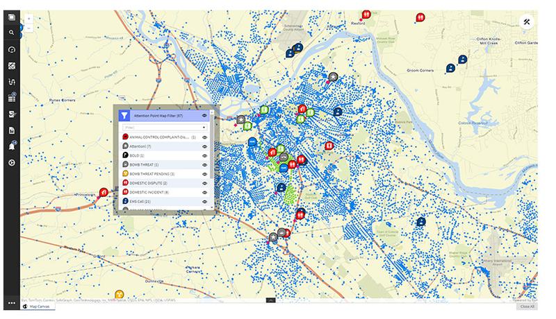
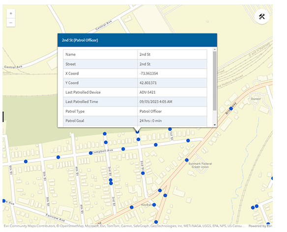
Patrolfinder uses Patrol Points and Attention Points to indicate where an officer needs to patrol. Patrol Points are located on your municipalities’ streets. Attention Points can be placed in any location that requires additional attention or officer awareness. As an officer patrols and passes through a designated Patrol Point or Attention Point, Patrolfinder will update the map to indicate the area has been patrolled and will automatically determine when the next patrol should occur. When each zone should be covered can be individually set based on data used to determine what areas need more of a police presence.
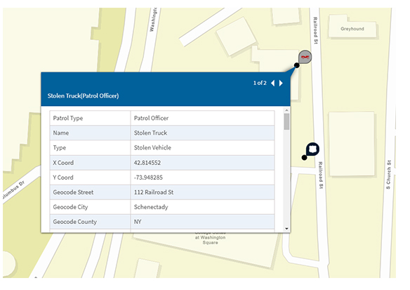
Bulletins also can be placed on the map to provide officers with the latest information on a potential crime scene.
In addition, utilize Patrolfinder’s White Board technology to collaborate with others on patrol matters.
Patrolfinder also aids with monitoring traffic enforcement.
What is an Attention Point?
Attention Points can be a set of X-Y coordinates or an NFC tag to identify a location that requires patrol in addition to an area’s Patrol Points.
Attention Points can be on a street but do not necessarily need to be. These are areas where there has been some sort of disturbance or concern raised, perhaps by a member of the community or an indoor location where you want to ensure a patrol has occurred.
Examples of Attention Points include: Property checks (vacation checks), public parks, gas stations, private residences, or rooms and areas located inside schools, apartment buildings, or businesses. In addition, events such as school dismissal, religious services, community events.
Officer Tools
1. Patrol Points
Stay informed about where patrols are happening and identify gaps in coverage.
- Overview: This feature provides real-time visibility into areas recently patrolled by officers. It ensures no region is overlooked, enhancing community safety and resource allocation.
- Enables strategic planning by showing historical and live patrol activity.
- Reduces redundancy and improves coverage in underserved areas.
- Supports data-driven decision-making to optimize patrol routes.
2. Attention Points
Focus your resources on areas that need immediate attention.
- Overview: This feature highlights zones requiring enhanced vigilance based on recent patrol data, reports, or emerging crime trends.
- Prioritizes areas flagged for frequent incidents or public concerns.
- Encourages proactive policing by addressing hotspots before issues escalate.
- Assists supervisors in monitoring focus areas for compliance and effectiveness.
3. Bulletins
All communication in one centralized location.
- Overview: Bulletins serve as a digital hub for vital communications, ensuring officers and administrators have immediate access to critical updates.
- Centralized repository for briefings, alerts, and shared documents.
- Easy search and filter options to quickly locate specific communications.
- Real-time updates to keep officers informed, even during active operations.
4. Navigation
Fast, reliable directions to points of emergency.
- Overview: Our built-in navigation tool provides real-time routing to emergency locations, factoring in traffic conditions, road closures, and situational updates.
- Turn-by-turn directions tailored to emergency response.
- Dynamic rerouting to avoid delays.
- Integration with patrol and attention points for seamless coordination.
Dispatcher Tools
1. Patrol Monitoring
Real-time oversight of officer activity in the field.
- Overview: This feature allows dispatchers to monitor patrols across the jurisdiction, providing up-to-date information on officer locations and activities.
- Live mapping of officer patrols with activity status updates.
- Customizable alerts for out of zone officers or unpatrolled areas.
- Historical data review for analysis and reporting.
2. Tracking Time in Zone
Monitor and manage time spent in specific areas.
- Overview: This feature tracks how long officers spend in designated zones, ensuring resources are allocated effectively and that high-priority areas receive adequate attention.
- Automatic tracking of time spent in patrol and attention zones.
- Alerts for overextended or insufficient time in critical areas.
- Reporting tools for analyzing patrol distribution and effectiveness.
3. Emergency Response Planning
Coordinate swift and effective responses to critical incidents.
- Overview: This feature equips dispatchers with tools to plan, coordinate, and communicate emergency responses in real-time.
- Visual mapping of incident locations and nearby resources.
- Utilizes GIS information to create a mapped out plan for emergency situations.
- Integration with live updates from the field for situational awareness.
4. ETA Tracking
Monitor and predict arrival times with precision.
- Overview: This feature provides accurate, real-time Estimated Time of Arrival (ETA) tracking for officers en route to incidents, ensuring efficient resource deployment and communication.
- Live ETA calculations based on current traffic and road conditions.
- See multiple officers simultaneously to create action plans in real-time.
- Integration with navigation tools to suggest optimized paths.
Additional Tools for Safety Resource Officers
Tracking indoor patrols in complex facilities such as schools, hospitals, or office buildings requires precision and reliability. By integrating NFC (Near Field Communication) technology with GIS (Geographic Information Systems), our solution revolutionizes how indoor patrols are monitored and managed. This approach provides accurate tracking, detailed layout mapping, and actionable insights, ensuring that every corner of a building is covered with efficiency and accountability.
1. NFC-Enabled Indoor Patrol Tracking
Seamlessly monitor patrol activities within buildings.
- Overview: NFC tags placed strategically throughout indoor environments serve as checkpoints for patrol officers. Officers simply tap their device on the tag to log their presence and actions.
- Customizable NFC tags for specific locations or tasks.
- Instant logging of officer presence and timestamped activity.
- Alerts for missed or skipped checkpoints.
2. GIS-Driven Indoor Layout Maps
Visualize indoor patrols with precision.
- Overview: GIS tools enable the creation of detailed indoor maps, allowing for real-time tracking and visualization of patrols within buildings.
- Accurate indoor layout mapping, including floors, rooms, and corridors.
- Integration with NFC checkpoint data for real-time updates.
- Heatmaps and analytics to identify coverage patterns and trends.
3. Comprehensive Reporting and Analysis
Turn patrol data into actionable insights.
- Overview: The system captures and organizes data from NFC checkpoints and GIS maps into detailed reports, enabling better resource allocation and strategy development.
- Exportable logs of patrol activities, including timestamps and locations.
- Analytical tools to evaluate patrol coverage and efficiency.
- Long-term trend analysis for continuous improvement.
 "We want officers to be mindful that when they are patrolling neighborhoods that they are doing it in an equitable way. Patrolfinder will help us show the community that we are patrolling more equitably."
Chief Eric Clifford, Schenectady (NY) Police Department
Media Inquiries
Please click here for media files.
For additional information, please contact Rick D’Errico, Director, Public Relations. Office: (518) 723-8303 / Cell: (518) 857-3053 / Email: rderrico@transfinder.com


